Fortwährender Wandel
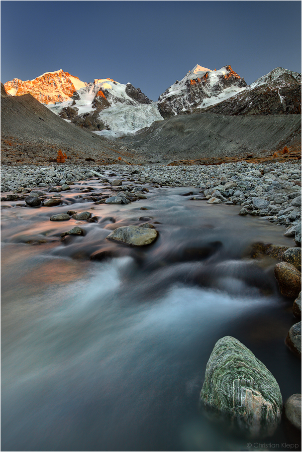
Das Alpenglühen taucht die Steilwand des 4048 m hohen Piz Bernina mit seinem vergletscherten Biancograt sowie die gratigen Gipfel des Piz Roseg (3937 m) mit der 3918 m hohen Schneekuppe in spätherbstliche Sonnenuntergangsfarben. Der aus dieser Region gespeiste Tschiervagletscher ist 4.5 km lang und etwa 1 km breit. Die mächtigen Seitenmoränen vom Gletscherhöchststand von 1850 nach lassen erahnen, um wieviel mächtiger der Gletscher zu dieser Zeit war. Auf etwa 2160 m Höhe entspringt die Ova da Roseg dem Gletscher, die ihr Wasser dem Inn zuführt. Die Berninagruppe im Südosten der Schweiz gehört geologisch zum Unterostalpin und ist ein Überbleibsel der Region, wo der vom Nordrand der Adriatischen Kontinentalplatte (Italien und Adria) abgescherte Mikrokontinent Ostalpin in den Penninischen Ozean überging. Entsprechend sind die vorherrschenden Gesteine sowohl kontinental-granitischen als auch submarin-vulkanischen Ursprungs. Piz Bernina besteht aus Diorit und Gabbro, das die kontinental-kristallinen Grundgebirge an der unteren Basis der Kontinente aufbaut. Diese Gesteine entstanden schon während der variszischem Gebirgsbildung vor 300 Millionen. Unterhalb dieser Gesteine lagern 125 Millionen Jahre alte Schutthalden ozeanischer Rutschungen, sogenannter Turbidite, die am Kontinentalrand entstanden. Zusätzlich finden sich Tiefseesedimente des Penninischen Ozeans. Beim rechts im Vordergrund befindlichen Gestein handelt es sich um zu Serpentinit umgewandelten vulkanischen Ozeanboden und damit um Zeugen der ehemaligen Spreizungszone des Penninischen Ozeans.
Oktober 2011
Canon 5D MkII, Canon L 16-35 mm, f/16, 2 Sek, 100 ASA, Polarisationsfilter
Mehr Information:
http://www.lichtjahre.eu
Where Geocscience Meets Art
------------------------------------------
Perpetual Change
In late fall the Alpenglow spellbinds the steep flanks of 13280 ft (4048 m) high Piz Bernina with its glaciated ridge Biancograt. The rising shades almost reached the jagged peaks of Piz Roseg (12916 ft, 3937 m) and its 12854 ft (3918 m) high Schneekuppe. This snow accumulation region nourishes the Tschierva glacier of 2.8 mi (4.5 km) length and 0.6 mi (1 km) width. The huge lateral moraines from the last glacial maximum of 1850 indicate the vast volume of the glacier at that time. At an elevation of 7086 ft (2160 m) the creek Ova da Roseg originates at the mouth of the glacier that drains its water into the river Inn. The Bernina mountain range in the southeast of the Swiss Alps is geologically connected to the Lower East-Alpine nappe. This area contains the remains of the micro-continent East-Alpine that sheared forward off the Adriatic continent plate (Italy and Adriatic) bordering the Penninic Ocean to the North. Accordingly the rocks in this area originate from both continental-granitoide and submarine-volcanic types. Piz Bernina consists of Diorite and Gabbro, which are typical rocks of the deep continental crystalline bedrock. These rocks are about 300 million years old and were formed during the Variscan orogeny. Below these formations about 125 million years old turbidites are located. They originated from underwater rock avalanches that slided down the continental margin into the deep sea. Additionally, deep ocean sediments occur along with former volcanic ocean floor material of the Penninic Ocean that metamorphosed into picturesque green stones called serpentinite. A specimen of this rock type can be seen in the right foreground. October 2011
Canon 5D MkII, Canon L 16-35 mm, f/16, 2 sec, ISO 100, polarization filter
More information:
http://www.lichtjahre.eu
Where Geocscience Meets Art


† Richard der Loewe 17/07/2013 11:17
Gekonnt! Hier macht sich das Hochformat bezahlt!Fernsicht 06/05/2012 14:39
Eine wunderbare Aufnahme und Info ohne Ende. Klasse!!LG Guido
Marko König 24/03/2012 18:58
Klasse!Viele Grüße,
marko
Anla 18/03/2012 9:45
Ein echter Klepp :-)Glückwunsch zum tollen Bild und danke für die Erläuterungen.
Gruß anla
Markus Kaschewsky 17/03/2012 9:29
Eine schöne Aufnahme,gefällt mir
lg Markus
rudi roozen 11/03/2012 22:26
grossartig!!!!!!!!!!lg Rudi
JValentina 11/03/2012 21:10 Commento di voto
+Skandinavienfreund 11/03/2012 21:10 Commento di voto
PROMelanie Hinz 11/03/2012 21:10 Commento di voto
proRobert Hatheier 11/03/2012 21:10 Commento di voto
+++Vera Laake 11/03/2012 21:10 Commento di voto
***PRO***Helmut Schweiger 11/03/2012 21:10 Commento di voto
+Carsten Jensen 11/03/2012 21:10 Commento di voto
+°Tanja Peters° 11/03/2012 21:10 Commento di voto
-FotoDX 11/03/2012 21:10 Commento di voto
+